Flood ontology network
The flood ontology network gives support to the project use case on flood and surge management. After an analysis of the requirements for this application, we have developed these ontologies mainly reusing a good number of ontologies from the SWEET suite, the core sensor network ontology and several ontologies developed by Ordnance Survey.
As can be seen in the following figure, the ontology network used in the flood emergency planning scenario is composed of different modules that can be classified in different layers according to whether the ontology included in the module represents: domain-specific information required for the scenario, information required for the SSG4Env infrastructure, or upper-level information used to facilitate interoperability among the other modules.
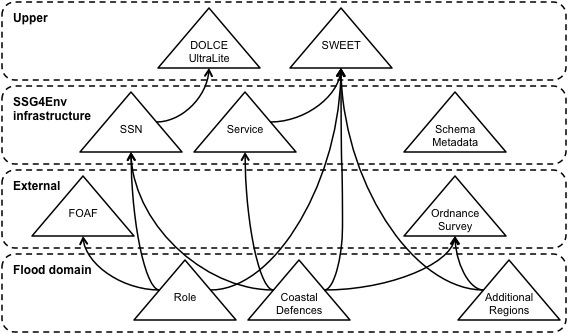
- To represent semantic sensor networks and their observed information about properties of certain features of interest. This is covered by the SSN ontology, developed inside the W3C Semantic Sensor Network Incubator Group, that reuses the DOLCE+Dns UltraLite upper ontology.
- To represent the services provided by the infrastructure and the datasets they provide access to. This is covered by the Service module that reuses the SWEET upper ontologies and includes concepts from the ISO19119 standard on geographic information services.
- To represent schema metadata about relations and relational streams. This is covered by the Schema Metadata module that was defined using ideas from the standard WebRowSet XML Schema definition and an ontology for relational data and schema components.
- To represent the geographic and administrative regions in the South coast of England. This is covered by the Ordnance Survey ontologies, which include the regions from Great Britain, and by the Additional Regions module, which includes other regions needed in our scenario.
- To represent those features of interest and their properties that are specific to the flood emergency planning scenario. This is covered by the Coastal Defences module.
- To represent the different roles involved in a flood emergency planning scenario. This is covered by the Roles module.
For further information, please contact Raúl García Castro or This e-mail address is being protected from spambots. You need JavaScript enabled to view it .
 |
SemSorGrid4Env - Semantic Sensor Grids for Rapid Application Development for Environmental Management SemSorGrid4Env is a joint project of seven European partners co-funded by the European Commission's Seventh Framework Programme under DG INFSO H.4 "ICT for Sustainable Growth", starting in September 2008 with a duration of three years. |
 |